Automated measurement of grain piles
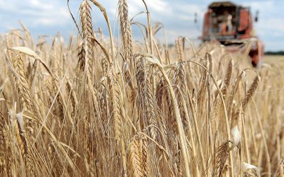
Inventory data of large piles of grains in warehouses or shipping stations are important for procurement, finance, and logistics. But it is quite hard to know the volumes of the raw materials. Drones can help, but fixed cameras are even better.
The use of imaging technology has seen a great flight in some sectors to help professionals to retrieve more relevant data, to gain better insights, and to make better decisions in their daily work. A great example of how images can help is seen in the ready-mixed concrete, gravel, rock, sand, and salt industries.
Stockpile Reports, a cutting-edge stockpile measurement solution, has been active in these industries since 2013. Recently, they announced their fixed-camera solution, which offers real-time measurement and the automation of inventory ordering. Their customers are using fixed cameras to measure the shape of inventory piles of salt, stones, gravel, etc. to gain insights on the inventory levels to help buyers and sellers understand how much product is left. The company has customers in 21 different industries and primarily sells to the US, followed by Australia and Europe. The mission of the company is to remove the guesswork when it comes to inventories. There is a need to know what’s actually on the ground and ready to sell. “We are a computer vision company, doing the image processing since 2011. At the time, we looked closely at which problems we could solve with image processing. We looked at 30-40 commercial business problems and inventory management in bulk industries came out as a sector with the greatest need for such a technology and the biggest market opportunity for what we had in mind”, explains David Boardman, CEO of Stockpile Reports.
Do not walk on stockpiles
We all have seen the big piles of rocks, gravel, sand or salt near warehouses, on industrial areas or near harbors. These materials come in huge volumes and are used for road construction or when in the case of salt, used to make the roads snow-free in winter times. Boardman: “It is really hard to track or measure material that doesn’t come into boxes and doesn’t have identification tags. Once the bulk materials are on location, it is impossible to do a perpetual inventory (a method of accounting for inventory that records the sale or purchase of inventory)”. Companies don’t know exactly what is going out and what is coming in. Guessing the levels can result in being 30-40% off. This is massive, considering that the big companies have up to hundreds of millions of dollars of inventory. The construction companies or governmental firms owning the bulk materials have to do a measurement of the inventories every year for the financial audit. “This used to be pure manual work. For the yearly measurement, surveyors would come in with GPS backpack and actually walk on these piles. You can imagine that this is a risky business and often people trip and fall during these measurements. Companies sometimes also used traditional imaging, done by planes. The problem with this is that it is not accurate enough and very costly,” explains Mr Boardman.
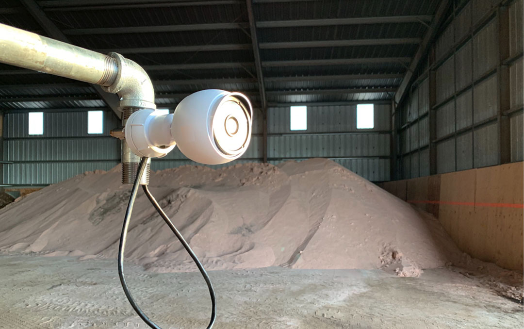
Fixed camera on salt piles
Stockpile Reports, therefore, introduced an iPhone app in 2013 to collect images via the phone. Drones came into play and became legal in the US and in 2015, Stockpile Reports added the capability to measure from both drones and airplanes. “Some companies have drones themselves but they can also call for one via us (just like an Uber). It is all about the fastest and cheapest way to get the pictures,” says Mr Boardman. The iPhone app and the use of drones make it possible for companies to do inventory counts, without the need to buy special hardware, more frequently than only once a year for the financial audit. “But the images we offer and the insights associated with that were appreciated that much by our customers that they requested to have measurements per year. Every month, or even every week or day. So the inventory insights were not only used by the financial people for the yearly tax report, but also the logistics and the procurements and salespeople started to use the data more often. Then we started to think of the fixed cameras because having a drone fly over the piles every week gets really expensive and time-consuming”, says Mr Boardman.

Saving time per order
Various low-cost fixed camera systems can be mounted in warehouses, shipping terminals, and storage yards to automatically calculate inventory levels, replacing the need for manual entry by humans. These fixed camera measurements can be scheduled to run at given times throughout the day, set to run on a recurring frequency interval, or automatically triggered after motion occurs. The cameras are monitoring the stockpiles all the time and when levels drop to a certain level, it triggers the system to take action (order more of the product for example).
The image data is used to create dashboards populated with photographs, site statistics, and materials report vital information on the volume, tonnage, and condition risks for each pile. The company has already installed a number of fixed cameras and just completed a five-month trial for a big salt company.
“Although early stages, we have seen from the trial results already that we are able to reduce around 30 minutes to place one order. I think the biggest savings can be found in better logistics, optimise trucks and as such delivering the materials much more efficient and on time than before. Think of efficiency gains in salt delivery when winter falls and the money saved to make sure materials are delivered on time”, Mr Boardman states.

Imagery potential in agriculture
The use of images is done in a variety of sectors. In agriculture, the use of images, taken by drones, planes or phones, make farming more efficient is growing at a rapid pace. Crop farmers and vineyard owners, for example, use aerial imagery or drones for images of their land and the quality of the crops and soil. In livestock farming, images are used to detect body condition scores or lameness patterns in dairy cows. Also, some companies, like Cainthus, are using imagery to assess animal behaviour and environmental changes that can affect production. “We are increasingly active in the agriculture industry, as this sector is digitalising itself more and more. Our technology to use phone and drone images is already used in the agricultural commodity industries such as stockpiles of grains, soy or maize at warehouses or in harbours”, explains Mr Boardman. The agricultural activities were spurred by the cooperation with BinMaster about a year ago. “BinMaster is expert in silo measurements of feed and they told us there is a need to be able to measure free-standing materials, such as the volumes of feed materials in the barn for example. That is where we found each other, they have a lot of experience in the feed world and we have a lot of experience in the rock, sand and gravel world. The cooperation entails that they sell our service, based on the phone and drone imaginary, on their website to the agricultural clients, next to their own solution they developed for the silos. Now, they are building the camera system for us and install them in the field. We are offering the software and generate the right measurements for the customers,” explains Mr Boardman.
Mr Boardman wants to grow further in the agriculture space as he sees that this sector is going through a fast digital transformation. “We haven’t yet installed the fixed cameras on farms to measure inventories, but we are testing this at the moment with an onion farmer (to measure the inventory piles of onions in the shed). We had fixed cameras placed at this farm about 7 months ago. But imagine the potential of images for other parts of the farm. Think of measuring the volume of large silage bunks or even for the forage levels in front of the cows in the barn. This could farmers provide with interesting insights that he can use for more efficient feeding or ordering,” says Boardman.
Join 26,000+ subscribers
Subscribe to our newsletter to stay updated about all the need-to-know content in the feed sector, three times a week.